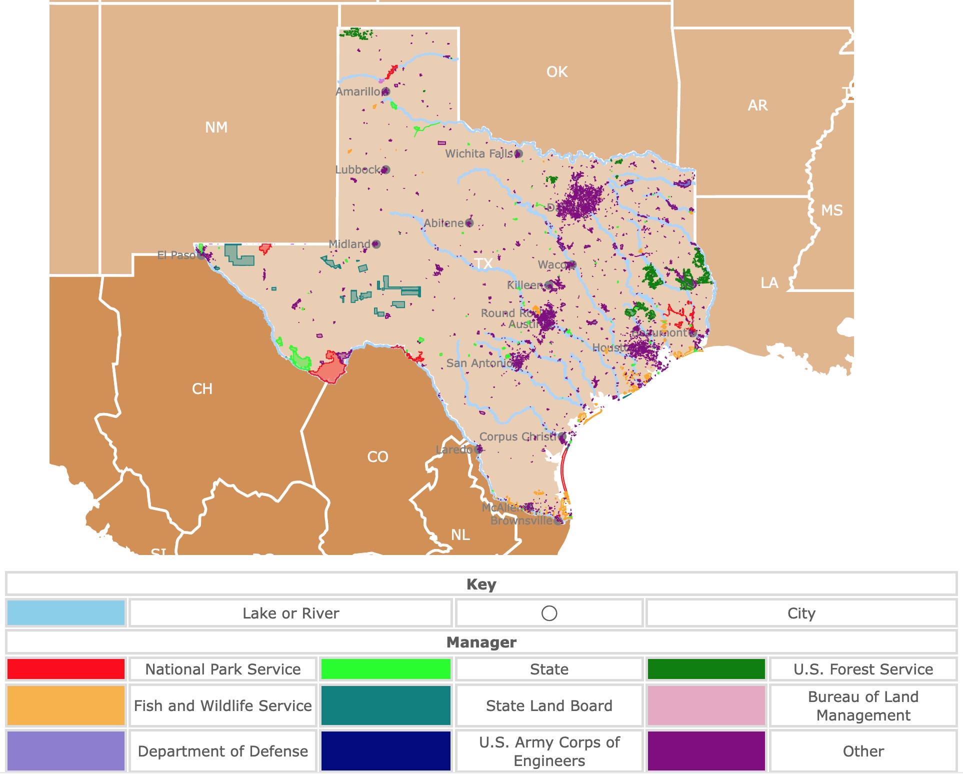
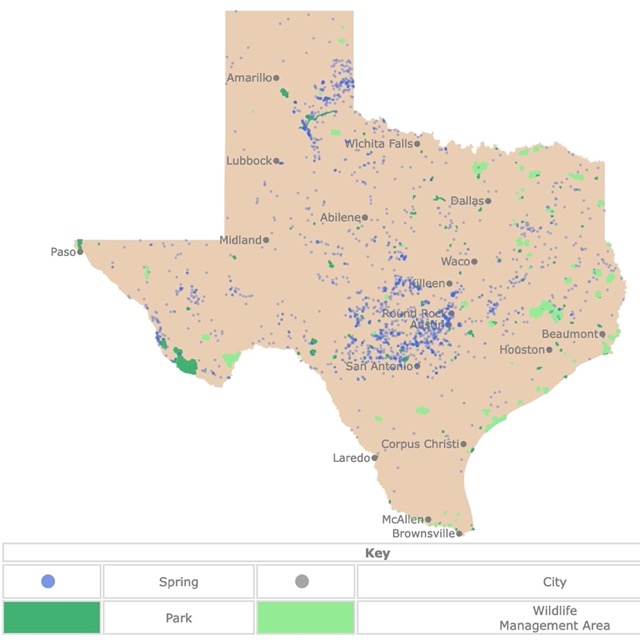
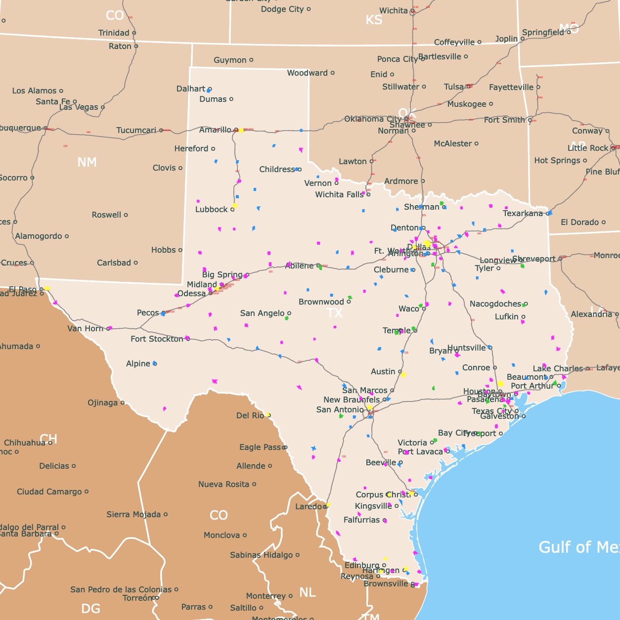
Map of Texas Parks
This interactive map shows the Locations, Names, Area, and details of National Parks, State Parks, National Forests, National Grasslands, and Wildlife Management Areas in Texas. It also shows major cities and rivers for context. For more detail zoom in. For more information, hover over the map, or scroll down.
| Key | |||||
|---|---|---|---|---|---|
| Lake or River | ◯ | City | |||
| Manager | |||||
| National Park Service | State | U.S. Forest Service | |||
| Fish and Wildlife Service | State Land Board | Bureau of Land Management | |||
| Department of Defense | U.S. Army Corps of Engineers | Other | |||
Texas Geography
Texas or the "Lone Star State" is the second largest state of the nation with 261,232 square miles.
Texas is bounded by New Mexico to the west, and Oklahoma to the north. It is bordered by Arkansas and Louisiana to the east.
To the southeast it is bordered by the Gulf of Mexico. To the southwest it shares an international border with Mexico.
Texas' geography could be described as a hilly in the southeastern side of the state. This area is also part of the Pine Belt where most of the state's timber grows.
Most of the forests are in the East Texas region. This is also because the water resources are more common to the east.
The central or interior of the state is characterized by lowlnads, where large ranches are found.
The Great Plains extend from the north of the state, all the way to Canada.
Far to the west Texas is a montainous region.
Map of Texas Counties
Texas Parks
The features of each park and natural area, display many of the characteristics of Texas regions and their geology.
Many of the State parks are in Hill Country. This area has water resources, the widest variety of landscapes, and the most diverse topography, ideal for recreation.
Only 5% of Texas lands is Public hence the importance of highlighting areas for the use of the general public.
Fortunately the most scenic and beautiful landscapes have been preserved for the enjoyment of all.
This Texas map has 13 National Parks, 119 State Parks and 80 Wildlife Management Areas, 4 U.S. National Forests, and 6 National Grasslands.
10 Most Popular Texas State Parks
To find the most popular State Parks in Texas I looked into Google Trends as a proxy. I searched for the most Related Queries for 'Texas State Parks'. These are the most common searches in order:
Garner State Park
Located 90 miles West of San Antonio, in the heart of Texas Hill Country is Garner State Park.
The park was created and gradually enlarged to its current size of 1,774 acres.
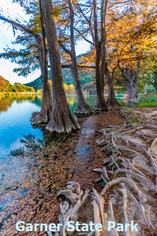
One of its main features is Mount Old Baldy, with 1,890ft (576m) rising over the surrounding landscape.
The best part of this mount is reaching the top and enjoying the views! It is ideal for challenging hikes, while you check the scenery and find the resident goats.
Other attractions include White Rock Cave and Crystal Cave. These caves are easy to explore, but you need to make sure you take the appropriate clothing for climbing. To find them, you must ask for information at the park's entrance.
The highlight of the park are the water activities.
At the Frio River it is possible to go tubing, fishing, kayaking, and swimming. Equipment rental is available on location.
If you are interested in taking your own raft, I would suggest you take this kayak found on Amazon: Intex Challenger K1 Kayak. This one person inflatable kayak is set with Aluminum Oars and High Output Air Pump. It is ideal for those who like to carry their own floatation device. It is inflatable, easy to pack, and easy to travel with.
There are picnic areas but the park also offers food at its Garner Grill. Backroads Texas
There are plenty of camping sites and tours if you plan to visit or stay the night!
Want to find more places to relax? Check this map of US Hot Springs
Colorado Bend State Park
Located 96 miles Northwest of Austin, in Texas Hill Country. Colorado Bend State Park used to be a ranch that now offers more than 5,000 acres of parkland.
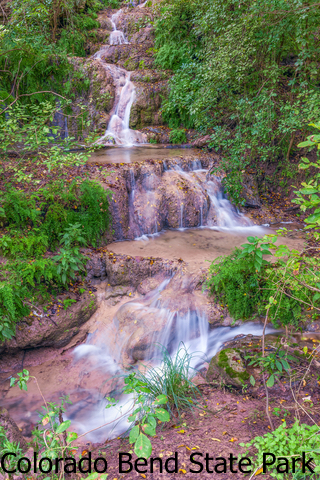
The first striking thing about this park is its undisturbed nature!
There are about 14 trails with over 30 miles to explore.
Because of its topography; hiking and biking trails have all sorts of terrain.
One of the main attractions of the park is Gorman Falls, with an incredible 70ft (21m) drop of water.. The advantage of these falls are that they run all year long, and not just during the rainy season.
The park offers different water bodies for a swim. There is Spicewood Springs, and 6 miles of the Colorado River.
The park has miles of caves to visit. You may rent safety gear and have a tour. You can also go to the small ones and take a quick look. Lone Star.
If you made it to the Lone Star State, but need a car, Expedia can help you find the right automobile. For prices and brands click here!
Tyler State Park
Located 95 miles East of Dallas, Tyler has over 600 acres of land for you to enjoy.
The property has a 64 acre spring fed lake in the middle of the park.
At the lake you can swim, fish, or take a boat. The lake has three fishing piers. From there you can cath crappie, perch, catfish, or bass.
The park has over 13 miles of trails for hiking and biking.
Bird watching and admiring 100ft (30m) trees in the woods make this a very special park to visit.
Tyler State Park is near Pineywoods ecoregion and Post Oak Savannah ecoregion. This results in a mix of plants from both ecoregions growing in the park. Tyler State Park
If you want to visit the park but do not want to spend the night camping, you can always stay at a nearby cabin or cottage. For amenities and dates visit VRBO.
Want to see more of Texas? Check this Map of Springs in Texas
Dinosaur Valley State Park
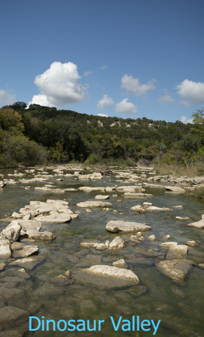
Located 90 miles Southwest of Dallas, Dinosaur Valley State park opened its doors in 1972 to preserve dinosaur track sites. The park is a 1,587 acre property.
As you arrive you will find the impressive Apatosaurus and Tyrannosaurus rex models. Perfect to get you in the mood of what you will encounter next.
Swim in the Paluxy River and later hike around the river to check the different sites with Dinosaur tracks. To take a closer look you may have to get wet.
Besides finding the tracks you can camp, hike, bike picnic, swim, fish, paddle, and watch wildlife.
You can also bring your own horse and explore the primitive area or take a guided tour on horseback or horse drawn wagon rides. Dinosaur Valley.
Lost Maples State Park Natural Area
This park is located 90 miles northwest of San Antonio, TX.
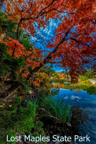
Situates in Texas Hill Country, this area has been inhabited by humans since prehistoric times.
The park was opened in 1979 and currently has 2,900 acres for the enjoyment of its visitors.
The emphasis of the property is preservation, hence the addition 'Natural Area' to tis name.
The park has an incredible display of bird and plant species.
The landscape is characterized by Maple trees, and is a local favorite to watch the changing colors of fall foliage.
There are about 10 miles of rocky and challenging trails.
Besides hiking there is also fishing. Nevertheless, stargazing is one of the most unforgettable experiences in the park. Because it is in such a natural and secluded location, it makes it almost free of light pollution. Source: BackroadsTexas.net
In case you want to get the most of stargazing, you can check this telescope found on Amazon Celestron - AstroMaster 130EQ Newtonian Telescope. This is a beginner's telescope, easy to carry and portable. Ideal to take to Lost Maples or other parks mentioned before. With this telescope you can observe Venus and Jupiter complete with four of its moons.
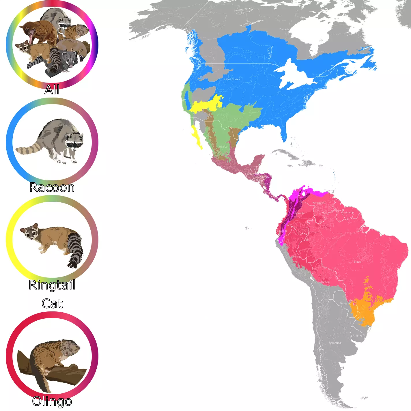
Map of Raccoons and Ringtailed cats
Inks Lake State Park
Located 70 miles Northwest of Austin. Inks Lake State Park has over 1,200 acres dedicated to nature and its visitors.
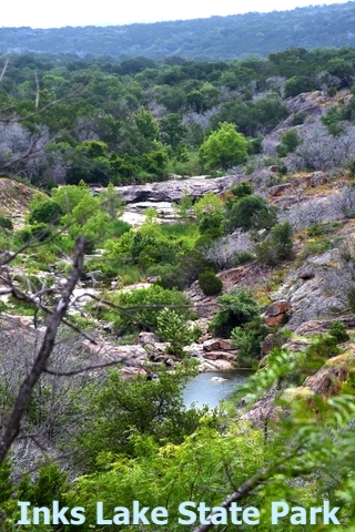
In the park it is possible to hike the 9 miles worth of trails. Admire nature, have a picnic or go camping.
The landscape is characterized by pink rocks sticking out through limestone. It is possible to learn more about the geology of the area thanks the geology hikes offered.
There is a great variety of animals to observe while at Inks Lake. It is likely to see white-tailed deer, racoons, squirrel, skunk, rabbit, armadillo, coyote, and fox. There are also owls, hummingbirds, geese, and poisonous snakes.
In the park you may find vegetation common to wet areas as well as arid areas. Moisture around the lake allows this disparity.
The park has mesquite, cedar, oaks, willows and more. There are also native grasses and cacti.
The best feature of the park are the lake and its views. Visitors can swim, go on a boat, scuba dive or fish. Boats and kayaks can be rented on site. Source: tpwd.texs.gov
If you have decided to visit Inks Lake, I suggest you pack these binoculars found on Amazon Gosky 10x42 Roof Prism Binoculars for Adults. They are HD Professional Binoculars for Bird Watching, Travel, and Stargazing. They come with a Lens Phone Mount, and Strap Carrying Bag. They will help you experience the best of the wildlife and the night skies.
Guadalupe River State Park
Situated 38 miles north of San Antonio, Guadalupe River State Park, must not be confused with Guadalupe Mountains National Park, which is further west.
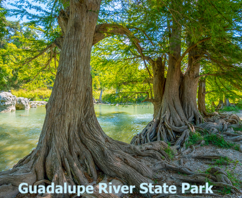
This is a family friendly park with 1,938 acres in Texas Hill Country.
The park has rolling green hills, limestone rocks, Juniper and oak trees scattered throughout. The oak and juniper woodlands have some grasslands mixed in.
The most prominent feature of the park is the four miles of the Guadalupe River frontage. The river is lined by gorgeous bald cypress trees and it is characterized by four natural rapids.
The park offers tours to learn more about the local flora and fauna. There is even a walk that pays special attention to bats!
There are 13 miles of hike and bike trails to explore. Texas Monthly
With such amazing scenery, uneven paths and terrain, I suggest you use these boots found on Amazon. They will provide comfort, while you enjoy your journey through the trails. Merrell Moab 2 Mid Waterproof Hiking Boot.
Map of Texas Airports
McKinney Falls State Park
Just 10 miles south of Downtown Austin, McKinney Falls State Park is inside city limits!
The most attractive feature of the park is its falls. They are the result of Onion Creek flowing over the limestone ledges.
There are nine miles of trails for hiking and biking. There are also opportunities for fishing, and swimming.
Before going remember the creek and falls water level changes during the year. There are times that they may be almost dry. The wet season is May to September! If you plan to take a plunge or admire the falls you need to keep this in mind. US News.
If you are in the area you might just spend a few nights in Austin. The city is the perfect contrast to this tranquil park. For details and prices visit Hotels.com.
Enchanted Rock State Natural Area
Located 95 miles Northwest of Austin, and right next to Fredericksburg.
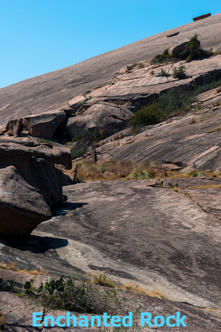
Named after its incredible granite dome rising over Hill Country. The top and bottom scenery has always been a magnet for visitors.
The dome seems to be durable but it is prone to erosion. It is also called an exfoliation dome since it has layers like an onion!
Enchanted rock is 425ft (129m) from base to top. The top is 1,825 feet (556m) above sea level. The whole dome is 640 acres.
There are spots on the dome that have weathered faster than others. These form Vernal Pools. They collect water and turn into microhabitats.
It is possible to hike, bike, or climb in the park and enjoy the landscape. Fredericksburg
In case you want to find an RV park, near these sites, this map of RV campgrounds might help you.
Palo Duro Canyon State Park
Just 25 miles South of Amarillo, this is the most scenic park in the Texas Panhandle.
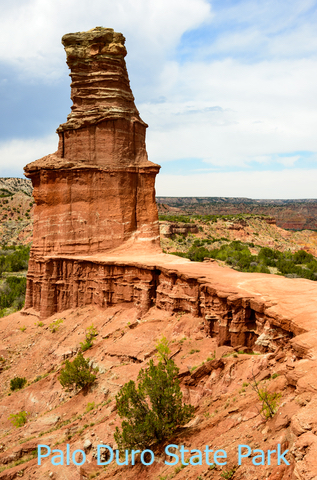
This is the second largest canyon in the country. It was formed by millions of years of water erosion from the 'Prairie Dog Town Fork Red River' (yes that is the name of the river).
Top to bottom the canyon can be 800ft (243m) high. The canyon is about 120 miles long and 20 miles wide.
While visiting, you may see HOODOOS, or rock formations that are larger rocks blanced on top of a smaller base. These are formed by rock layers that erode at different rates.
The different layers of the canyon display beautiful colors for visitors to admire. There are over 16 miles of paved roads that offer incredible scenic views.
The park also offers 30 miles of trails for biking, hiking or horseback riding.
Besides the endemic and incredible wildlife present, it is possible to see Longhorn cattle roaming around the park.
The canyon is characterized by Rocky Mountains Juniper, while the rim of the canyon has shortgrass prairie. The floor or bottom of the canyon has greater variety of flowers since that is where the river flows and water is concentrated. Palo Duro Canyon
Texas National Parks
In Texas, as in the rest of the country, there are different designations managed by the National Park Service. There are National Preserves, National Recreational Areas, National Monuments, etc.
The following are the two National Parks present in Texas.
Guadalupe Mountains National Park
Situated in West Texas, East of El Paso. The park is situated in the same mountain range as Carlsbad Caverns National Park in New Mexico.
This park has canyons, deserts, dunes, and beautiful landscapes.
McKittrick Canyon attracts many visitors specially during the Fall. Deciduous trees are not common in the area but thanks to the high elevation, beautiful reds, and oranges come alive.
Some of the vegetation changes color with the seasons, while the desert and the cacti keep the same colors.
The park protects the most extensive Permian Reef, which is located in McKittrick Canyon.
Guadalupe Mountains have the four highest peaks in Texas. The tallest is Guadalupe Peak with 8,751ft (2,667m) high.
The Salt Basin Dunes are the result of land movement over millions of years, that left a drained basin. All that is left is the gypsum grains as a sand deposit.
Besides all the incredible surrounding nature, it is also possible to see part of the native and pioneer history of West Texas. Guadalupe National Park.
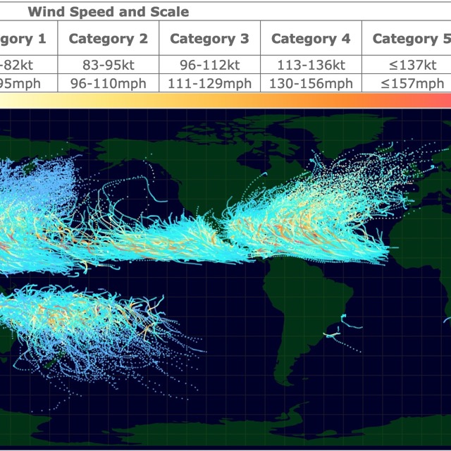
Map of Tropical Cyclones Worldwide
Big Bend National Park
Big Bend National Park is Located in West Texas. The park's South Border is the Rio Grande. South of the river is Mexico.
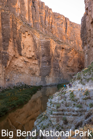
Elevations range from 1,800ft (548m) along the Rio Grande to 7,832ft (2,387m) on Emory Peak. The different altitudes result in a wide variety of plants and views throughout the park.
Because of the Parks large size there are multiple activities and sites to visit. If you are not sure what to see there are 100 miles of paved roads to check the scenery.
The park also has over 150 miles of trails. It is possible to camp, hike, boat down the river, or go horseback riding.
There are over 1,200 species of plants, including 60 cacti species. There are amphibians, reptiles, fish and 75 species of mammals.
The park has more types of birds, bats, butterflies, ants, scorpions and cacti than any other park in the U.S.
Big Bend is a paradise for geologists. Many geologic processes worked in the area and you will find rocks and strata at different angles. Some even look like they don't fit. There are also volcanic remains and vertical faults.
The park also has a largely intact 130 million years worth of fossils. The park has records of flourishing mammals to the demise of dinosaurs. Big Bend
Big Bend National Park and Big Bend Ranch State Park are next to each other and have been awarded International Dark Skies Association designations. This means they are ideal places to watch stars, without light pollution.
Texas National Forests
Texas has six National Grasslands, all located north of the state. Texas also has four National Forests, north of Beaumont, very close to each other.
Sam Houston National Forest
Sam Houston is located 50 miles north of Houston. The forests area is 167,000 acres, and is one of four national forests in Texas.
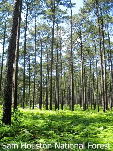
The forest is managed under a multiple use concept. This means the area is used for recreation, fishing, hunting, timber, and grazing; maintaining a balance and providing public needs.
A fun activity is to hike the 128 mile Lone Star Hiking Trail throughout the forest.
Visitors avoid the hike during the summer months, to avoid the excessive heat. Visitors also avoid the trail between November and December, as this is hunting season.
While walking you are likely to walk into creeks and lakes. There is fishing and boating available at the park. It is also possible to bike and go horseback riding through the trails.
Hunting for deer, squirrel, duck and quail are popular activities at the forest. Other wildlife worth viewing are bald eagles, and woodpeckers. Sam Houston National Forest.
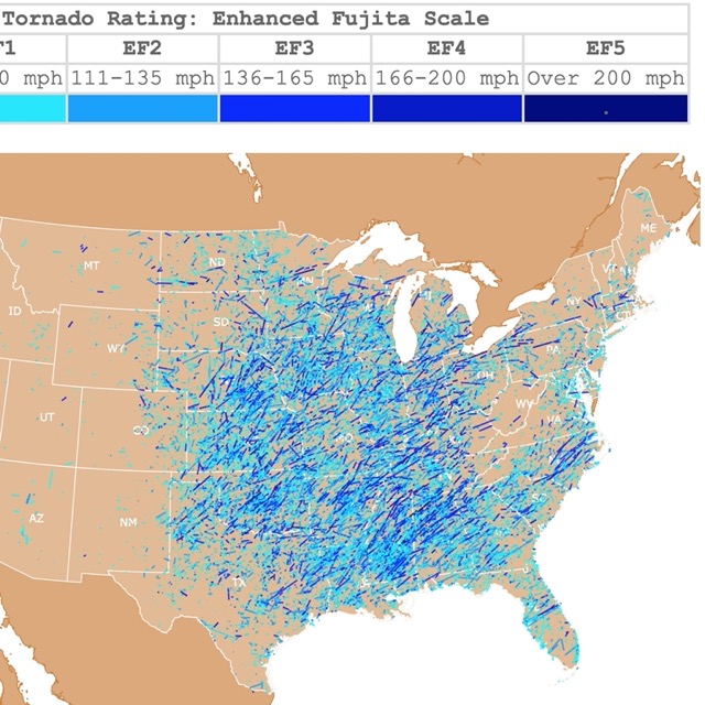
Map of Tornadoes in the U.S.A.
List of Parks in Texas
This list includes National Parks, State Parks, National Forests, and other protected areas from Texas.
| National Parks | |
|---|---|
| Big Bend National Park | Guadalupe Mountains National Park |
| National Historical Park | |
| Lyndon B. Johnson National Historical Park | |
| National Memorial | |
| Chamizal National Memorial | |
| National Historic Site | |
| Fort Davis National Historic Site | |
| National Historic Park | |
| San Antonio Missions National Historic Park | |
| National Monument | |
| Alibates Flint Quarries National Monument | |
| National Recreation Areas | |
| Amistad National Recreation Area | Lake Meredith National Recreation Area |
| National Seashore | |
| Padre Island National Seashore | |
| National Preserve | |
| Big Thicket National Preserve | |
| State Parks | |
| Abilene State Park | Jim Hogg State Park |
| Atlanta State Park | Kerrville State Park |
| Avalon State Park | Kickapoo Cavern State Park |
| Balmorhea State Park | Lake Arrowhead State Park |
| Bastrop State Park | Lake Bob Sandlin State Park |
| Bentsen Rio Grande Valley State Park | Lake Brownwood State Park |
| Big Bend Ranch State Park | Lake Casa Blanca International State Park |
| Big Spring State Park | Lake Colorado City State Park |
| Birch Creek State Park | Lake Corpus Christi State Park |
| Blanco State Park | Lake Livingston State Park |
| Bonham State Park | Lake Mineral Wells State Park and Trailway |
| Brazos Bend State Park | Lake Somerville State Park Trailway |
| Buescher State Park | Lake Somerville State Park Trailway |
| Caddo Lake State Park | Lake Tawakoni State Park |
| Caprock Canyons State Park | Lake Whitney State Park |
| Cedar Hill State Park | Lockhart State Park |
| Choke Canyon State Park | Longhorn Cavern State Park |
| Cleburne State Park | Martin Dies, Jr. State Park |
| Copano Bay Causeway State Park | Martinez State Park |
| Copper Breaks State Park | McKinney Falls State Park |
| Daingerfield State Park | Meridian State Park |
| Davis Mountains State Park | Mission Tejas State Park |
| Dinosaur Valley State Park | Monahans Sand Hills State Park |
| Eisenhower State Park | Monument Hill State Park |
| Fairfield Lake State Park | Mother Neff State Park |
| Falcon State Park | Palmetto State Park |
| Fannin State Park | Mustang Island State Park |
| Fort Griffin State Historic Site | Palmetto State Park |
| Fort Parker State Park | Palo Duro Canyon State Park |
| Franklin Mountains State Park | Pedernales Falls State Park |
| Galveston Island State Park | Possum Kingdom State Park |
| Garner State Park | Purtis Creek State Park |
| Goliad State Park | Ray Roberts Lake State Park |
| Goose Island State Park | San Jacinto State Park |
| Guadalupe River State Park | Seminole Canyon State Park |
| Huntsville State Park | South Llano River State Park |
| Inks Lake State Park | Stephen F. Austin State Park |
| Inks Lake State Park | Texas State Park |
| Tyler State Park | |
| State Forests | |
| Fairchild State Forest | W G Jones State Forest |
| State Historic Sites | |
| Acton State Historic Site | Washington-on-the-Brazos State Historic Site |
| State Natural Areas | |
| Enchanted Rock State Natural Area | Lost Maples State Natural Area |
| National Forests | |
| Angelina National Forest | Sabine National Forest |
| Davy Crockett National Forest | Sam Houston National Forest |
| National Grassland | |
| Caddo-Lyndon B. Johnson National Grasslands | Rita Blanca National Grassland |
| McClellan Creek National Grassland | Black Kettle National Grassland |
| National Wildlife Refuges | |
| Anahuac National Wildlife Refuge | Laguna Atascosa National Wildlife Refuge |
| Aransas National Wildlife Refuge | Muleshoe National Wildlife Refuge |
| Brazoria National Wildlife Refuge | San Bernard National Wildlife Refuge |
| Buffalo Lake National Wildlife Refuge | Santa Ana National Wildlife Refuge |
| Hagerman National Wildlife Refuge | Texas Point National Wildlife Refuge |
FOLLOW ME
Sources for Texas Parks Map
The shapefiles with state parks, forests, national parks, and wildlife polygons were downloaded from ScienceBase.
The shapefiles with the Texas state boundary were downloaded from Texas Dept. of Transportation.
This map will be updated with new data! To receive updates on this and more nature maps join my email list!!!!!!!
Made by Luz K. Molina with D3.js.