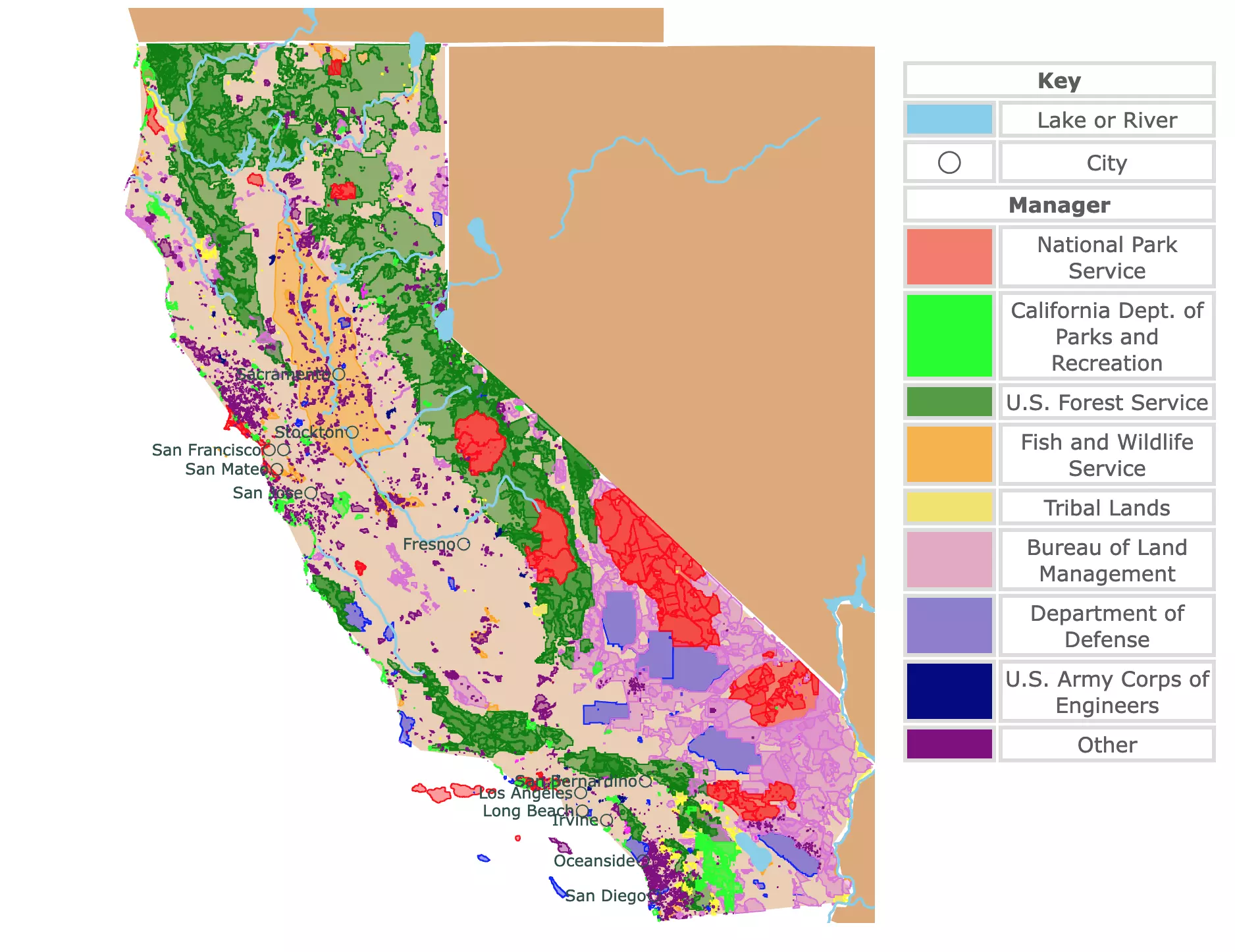
Map of California's Protected Areas
This interactive map shows the Locations, Names, Areas, and Details of National Parks, State Parks, National Forests, Tribal, and other Public Lands of California. It also shows major cities and rivers for context. For more detail, zoom in. For more information, hover over the map, or scroll down.
| Key | |
|---|---|
| Lake or River | |
| ◯ | City |
| Manager | |
| National Park Service | |
| California Dept. of Parks and Recreation | |
| U.S. Forest Service | |
| Fish and Wildlife Service | |
| Tribal Lands | |
| Bureau of Land Management | |
| Department of Defense | |
| U.S. Army Corps of Engineers | |
| Other | |
California
Called The Golden State because of the Gold Rush in the 1800s, California is an economic powerhouse and a center of population.
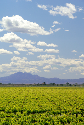
California is the most populous state in the United States, with 40 million people.
With 58 counties and about 1,000 miles of coastline, this is a state of contrasts. In California, you can go surfing, skiing, hiking in forested mountains, or go for a stroll in the desert.
California's climate could be described as mild. This is thanks to the California current that comes from Alaska. Cool maritime air masses moderate the heat from the desert.
If you want to learn more about the Pacific Coast, visit North America's Marine Ecoregions Map
California's Natural and Protected Areas
The Golden State's geography is the perfect setting for an incredible array of parks and natural areas for visitors to enjoy.
California has 9 National Parks, more than any other state. They are not just beautiful; they are also quite diverse, scenic, and some of the most accessible in the country!
Besides the National Parks, the National Park Service manages Wilderness Areas, Recreation Areas, Preserves, and others. These areas are represented in red on the map above.
California's National Parks are:
- Channel Islands
- Death Valley
- Joshua Tree
- Lassen Volcanic
- Lava Beds
- Pinnacles
- Redwood
- Sequoia & Kings Canyon
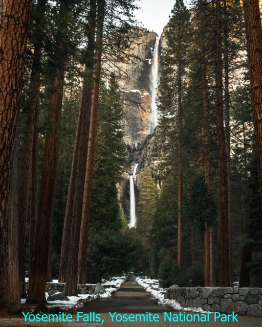
- Yosemite
If all these National Parks are not enough, California has over 200 areas managed as State Parks. California's state park system is one of the biggest and most diverse park systems in the U.S. The state parks are represented in lime green on the map above.
California also has 20 National Forests. These forests are mainly located in the Cascades and in the Sierra Nevada. National Forests and Wilderness Areas managed by the USFS are represented in dark green on the map.
The Bureau of Land Management oversees 15 million acres of public lands in California, about 15% of the Golden State’s total landmass. Because of their use, these lands are not just for conservation and recreation. They are also used for foresting, mining, and grazing. BLM.gov
California's Best National Parks
Making a list of California's best Parks could be limited to just its National Parks. Nevertheless, this list tries to include other designations and protected areas that may be enjoyed by visitors.
These are California's most-searched parks and natural areas on Google trends.
Sequoia & Kings Canyon National Parks
Sequoia & Kings Canyon National Parks are located east of Fresno and are represented in red on the map above.
The main attraction of this park is the giant sequoias, the largest tree in the world.
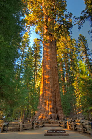
Besides their size, sequoias stand out from other trees by their red and orange bark color, which is different from other gray and brown tree trunks.
These giants grow between 4,000 and 8,000 feet (1,219 and 2,438 m) in elevation along the west slope of the Sierra Nevada. These are not the oldest trees, but they can live around 3,400 years.
Sequoia groves are mixed conifer forests with giant sequoias. These mixed groves allow for a more visually striking experience.
Giant Forest is one of the many groves tourists can visit. This grove has the largest sequoias, including General Sherman, the largest one of all.
Sequoias are not just carbon sinks and an attraction for visitors. Their tree rings are a valuable record of climate fluctuations in the past.
Given their location, sequoias have evolved with fire. Their bark protects the trees against fires, and it is not rare to see trees with scars from past blazes.
Fires are also important as they promote seedlings to grow. Bare and barren mineral soil, left by fires, is indispensable for sequoia seeds to germinate. Sequoia.
For an unforgettable vacation near Sequoia and Kings Canyon, VRBO has the place for you. With over 400 vacation rentals in the area, you can plan your perfect trip. For more information, click here!
Map of Earthquakes Worldwide
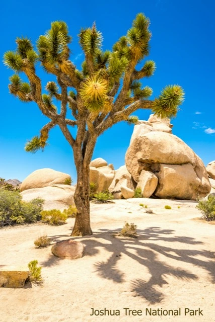
Joshua Tree National Park
Joshua Tree is a desertic environment east of Los Angeles. This park is characterized by its granite monoliths and boulder formations.
This is a rainshadow desert as the mountains block the rain from reaching this area.
Daily high and low temperatures can vary as much as 50°F (28°C).
Joshua Tree has two recognizable desert ecosystems, Colorado and Mojave.
For a tranquil stay with breathtaking & uninterrupted desert landscape and mountain vistas, VRBO has a beautiful property within 5minuts of the park. To get reservation GO HERE!
If you just want to check flights type them below, Expedia can help.
Mojave Desert
The western half of Joshua Tree National Park ranges from 2,000 to 5,000 feet (609m-1,524m) in elevation.
The desert receives about 3-5 inches (76.2-127mm) of rain annually, most of which occurs during the winter.
The Mojave Desert has a slightly cooler climate than the Colorado Desert and is also recognized by the Joshua Trees (Yucca brevifolia) native to this region.
Colorado Desert
The eastern half is part of the Colorado Desert, also part of the Sonoran Desert. This is one of the aridest regions in North America.
It is characterized by low elevations (<2,000 feet or <609m), hotter temperatures, and less rainfall than the Mojave Desert.
The Colorado Desert may appear barren but it supports a greater diversity of plants and animals than the Mojave desert. Nevertheless, the Joshua Tree is absent here.
Pinyon Pine and Juniper Zone
There is also a third ecosystem in the park. It is at high elevations, and it hosts pinyon pine and juniper trees. This woodland provides shelter and shade in the highest mountains. Source: USGS.
Joshua Tree Wildlife
Not much wildlife is visible during the daytime since most of its inhabitants are nocturnal. Most of them are active after dark.
Some of Joshua Tree's inhabitants include coyotes, bobcats, mountain lions, golden eagles, and the Mojave Desert Tortoise.
If your interest is geared toward the stars, this park was recently designated as an International Dark Sky Park.
For detailed maps of deserts in California, Amazon has California Desert National Parks. The pack includes three maps that cover the Joshua Tree, Death Valley, and Mojave National Preserve.
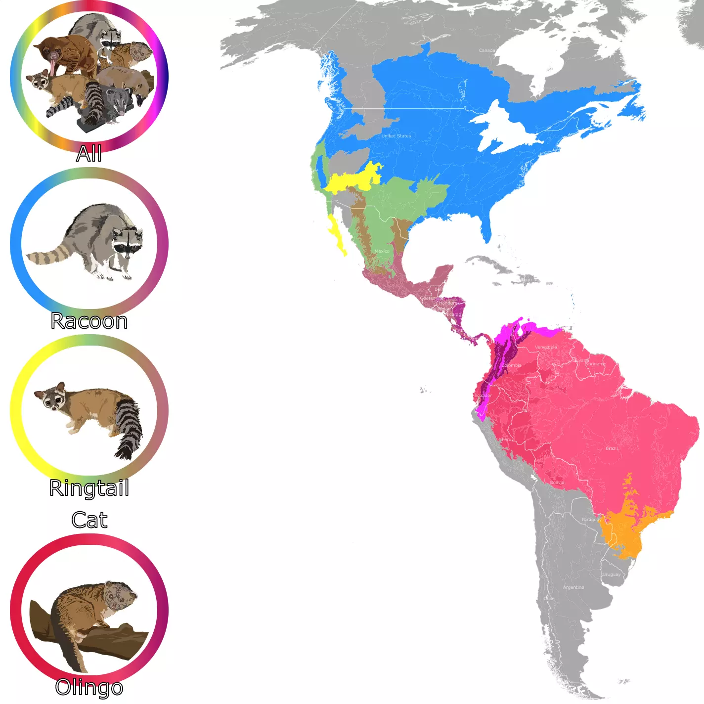
If you want to learn more about the raccoon and ring-tailed cats living in California, check this map of the Raccoon Family Geographic Range
Redwood National and State Parks
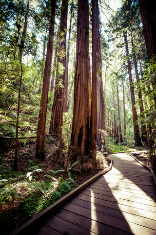
Redwood is along the Pacific Coast and close to the Oregon border.
This unique site is the partnership between 3 state parks, Jedediah Smith Redwoods State Park, Del Norte Coast Redwoods State Park, and Prairie Creek Redwoods State Park, plus Redwood National Park.
Redwood's weather is moderated by the Pacific Ocean, with temperatures ranging from 50°F to 60°F (10°C to 15°C). Summers are dry, and winters are rainy.
These parks are recognized for having the tallest trees in the world, the massive coastal Redwood. Visitors can also see mosses ferns and the scenic coastline of northern California.
The best hike in the park is Tall Trees Grove. This grove is home to the tallest tree, Hyperion, with 379 feet (115m). Source: Redwood.
You can stay in a cozy cabin 12mi from Redwood National Park. At Emerald Forest Cabins you will be inside a forest with the amenites of comfortable home. To book go to Expedia.
Death Valley National Park
Situated east of Fresno, close to the border with Nevada, this is a park of extremes.
Death Valley has recorded the hottest temperature on Earth, 134°F (57°C).
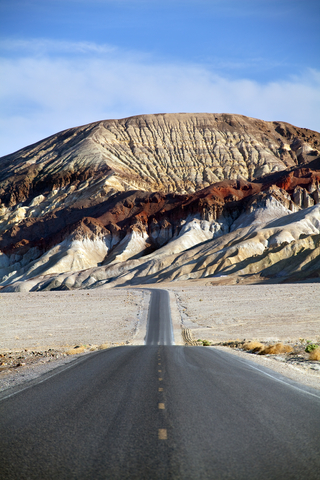
Death Valley is also the driest U.S. National Park; in addition, it features the lowest elevation in North America with -282ft (86m).
Death Valley is an adventure waiting for visitors to experience. There are majestic dunes, slot canyons, salt flats, and rocky peaks for visitors to explore.
Despite being a desert, Death Valley has more than 1,000 plant species, from ancient bristlecone pines to spring wildflowers.
This plant diversity is thanks to 11,000 feet (3,352m) of elevation change.
The park is also known for spectacular spring blooms. Nevertheless, they don't occur every year. Perfect conditions allow for this event to happen and lure visitors. Source: Death Valley.
For a fun experience in California and its parks, you can get this guide found on Amazon. Moon California Hiking: The Complete Guide to 1,000 of the Best Hikes in the Golden State. It has a hike for everyone, coastal walks, and challenging backcountry treks, with options ranging from easy day hikes to multi-day backpacking trips.
Lassen Volcanic National Park
Lassen volcanic National Park is one of California's most visited National Parks. One could describe it as a smaller version of Yellowstone.
The park is capped by 10,462-foot Lassen Peak, the world’s largest volcanic dome.
The park offers miles of trails, among volcanic and hydrothermal features.
In winter, the park is known to turn into a winter wonderland!
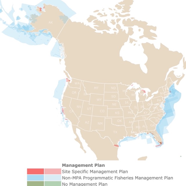
California has a long coastline and many marine ecosystems to protect. To learn more, check out this map of U.S. Marine Protected Areas
Califirnia's Most Popular State Parks
Pfeiffer Big Sur State Park
West of Fresno, on the western slope of the Santa Lucia Mountains, right by the Pacific Coast, is Pfeiffer Big Sur.
Visitors enjoy walking by the banks of the Big Sur River, redwoods, conifers, sycamores, cottonwoods, alders, oaks, maples, willows, open meadows, and waterfalls.
The park has no access to the beach, but visitors may find some ocean views. The main attraction is the nature trails for hikers to explore. Source: Big Sur.
Crystal Cove State Park
Crystal Cove is just south of Los Angeles by the Pacific Coast. This park has a Mediterranean climate, foggy summer mornings, warm days, and cool evenings.
Crystal Cove State Park has rolling surf, sandy beaches, tidepools, sloping hills, deeply wooded canyons, and ridges.
Crystal Cove is visited by hikers, swimmers, and surfers. Source: Crystal Cove.
For flights, hotels, prices, and dates, don't hesitate to check Expedia. It has incredible packages to visit Los Angeles!
Big Basin Redwoods State Park
Located just south of San Jose, by the California Coast, on the Santa Cruz Mountains. This is California's oldest state park.
The biggest attraction of the park is the Redwood trees. The trees may be 305 feet (93m) tall, 50 feet (15m) round, and even 1,500 years old!
The park also has mixed conifer, oaks, chaparral, and riparian habitats. Source: Big Basin.
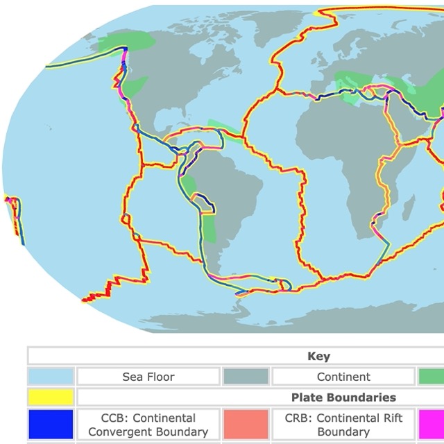
Want to learn more about California's Geology? Visit this map of Tectonic Plates and Boundaries
Red Rock Canyon State Park
North of Los Angeles, is a lime green speck on the southernmost tip of the Sierra Nevada.
This scenic park has desert cliffs, buttes, and rock formations. Visitors enjoy viewing the dramatic shapes and lively colors.
The park has different canyons with distinctive features.
Like other sites in the state, this park blooms after winter with spring rains. Source: Red Rock.
California's State Park List
This list includes California's State Parks and Natural Areas organized by county.
| County | Park |
|---|---|
| Alameda | Albany State Marine Reserve |
| Bethany Reservoir State Recreation Area | |
| Lake Del Valle State Recreation Area | |
| Robert W. Crown Memorial State Beach | |
| Eastshore State Park | |
| Emeryville Crescent State Marine Reserve | |
| Carnegie State Vehicular Recreation Area | |
| Alpine | Grover Hot Springs State Park |
| Amador | Indian Grinding Rock State Historic Park |
| Butte | Bidwell Mansion State Historic Park |
| Butte City Project | |
| Clay Pit State Vehicular Recreation Area | |
| Lake Oroville State Recreation Area | |
| Bidwell-Sacramento River State Park | |
| Calaveras | Calaveras Big Trees State Park |
| Colusa | Colusa-Sacramento River State Recreation Area |
| Contra Costa | Cowell Ranch/John Marsh State Historic Park |
| Franks Tract State Recreation Area | |
| Mount Diablo State Park | |
| Del Norte | Del Norte Coast Redwoods State Park |
| Jedediah Smith Redwoods State Park | |
| Pelican State Beach | |
| Tolowa Dunes State Park | |
| El Dorado | D. L. Bliss State Park |
| Ed Z’berg Sugar Pine Point State Park | |
| Emerald Bay State Park | |
| Lake Valley State Recreation Area | |
| Marshall Gold Discovery State Historic Park | |
| Washoe Meadows State Park | |
| Auburn State Recreation Area | |
| Folsom Lake State Recreation Area | |
| Fresno | Millerton Lake State Recreation Area |
| Humbolt | Azalea State Natural Reserve |
| Benbow Lake State Recreation Area | |
| Fort Humboldt State Historic Park | |
| Grizzly Creek Redwoods State Park | |
| Harry A. Merlo State Recreation Area | |
| Humboldt Lagoons State Park | |
| Humboldt Redwoods State Park | |
| John B. Dewitt Redwoods State Natural Reserve | |
| Little River State Beach | |
| Patrick’s Point State Park | |
| Prairie Creek Redwoods State Park (Fern Canyon) | |
| Richardson Grove State Park | |
| Trinidad State Beach | |
| Imperial | Heber Dunes State Vehicular Recreation Area |
| Picacho State Recreation Area | |
| Salton Sea State Recreation Area | |
| Ocotillo Wells State Vehicular Recreation Area | |
| Kern | Fort Tejon State Historic Park |
| Red Rock Canyon State Park | |
| Tomo-Kahni State Historic Park | |
| Tule Elk State Natural Reserve | |
| Lake | Anderson Marsh State Historic Park |
| Clear Lake State Park | |
| Los Angeles | Antelope Valley California Poppy Reserve |
| Antelope Valley Indian Museum State Historic Park | |
| Arthur B. Ripley Desert Woodland State Park | |
| Castaic Lake State Recreation Area | |
| Dockweiler State Beach | |
| Kenneth Hahn State Recreation Area | |
| Los Angeles State Historic Park | |
| Los Encinos State Historic Park | |
| Malibu Creek State Park | |
| Malibu Lagoon State Beach | |
| Pio Pico State Historic Park !Pío Pico State Historic Park | |
| Placerita Canyon State Park | |
| Rio de Los Angeles State Park | |
| Robert H. Meyer Memorial State Beach | |
| Saddleback Butte State Park | |
| Santa Monica State Beach | |
| Santa Susana Pass State Historic Park | |
| Topanga State Park | |
| Verdugo Mountains | |
| Watts Towers of Simon Rodia State Historic Park | |
| Will Rogers State Beach | |
| Will Rogers State Historic Park | |
| Hungry Valley State Vehicular Recreation Area | |
| Leo Carrillo State Park | |
| Madera | Wassama Round House State Historic Park |
| Marin | China Camp State Park |
| Marconi Conference Center State Historic Park | |
| Mount Tamalpais State Park | |
| Olompali State Historic Park | |
| Samuel P. Taylor State Park | |
| Tomales Bay State Park | |
| Angel Island State Park | |
| Mariposa | California State Mining and Mineral Museum |
| Mendocino | Admiral William Standley State Recreation Area |
| Caspar Headlands State Beach | |
| Caspar Headlands State Natural Reserve | |
| Greenwood State Beach | |
| Hendy Woods State Park | |
| Jug Handle State Natural Reserve | |
| MacKerricher State Park | |
| Mailliard Woods State Natural Reserve | |
| Manchester State Park | |
| Mendocino Headlands State Park | |
| Mendocino Woodlands State Park | |
| Montgomery Woods State Natural Reserve | |
| Navarro River Redwoods State Park | |
| Point Cabrillo Light Station State Historic Park | |
| Reynolds Wayside Campground | |
| Russian Gulch State Park | |
| Schooner Gulch State Beach | |
| Smithe Redwoods State Natural Reserve | |
| Standish-Hickey State Recreation Area | |
| Van Damme State Park | |
| Westport-Union Landing State Beach | |
| Sinkyone Wilderness State Park | |
| Merced | George J. Hatfield State Recreation Area |
| Great Valley Grasslands State Park | |
| McConnell State Recreation Area | |
| San Luis Reservoir State Recreation Area | |
| Pacheco State Park | |
| Mono | Bodie State Historic Park |
| Mono Lake Tufa State Natural Reserve | |
| Monterey | Andrew Molera State Park |
| Asilomar State Beach | |
| Carmel River State Beach | |
| Fort Ord Dunes State Park | |
| Garrapata State Park | |
| Hatton Canyon | |
| John Little State Natural Reserve | |
| Julia Pfeiffer Burns State Park | |
| Limekiln State Park | |
| Marina State Beach | |
| Monterey State Historic Park | |
| Monterey State Beach | |
| Pfeiffer Big Sur State Park | |
| Point Lobos Ranch | |
| Point Lobos State Natural Reserve | |
| Point Sur State Historic Park | |
| Fremont Peak State Park | |
| Salinas River State Beach | |
| Zmudowski State Beach | |
| Moss Landing State Beach | |
| Napa | Bale Grist Mill State Historic Park |
| Bothe-Napa Valley State Park | |
| Robert Louis Stevenson State Park | |
| Nevada | Empire Mine State Historic Park |
| Malakoff Diggins State Historic Park | |
| South Yuba River State Park | |
| Donner Memorial State Park | |
| Orange County | Bolsa Chica State Beach |
| Corona del Mar State Beach | |
| Crystal Cove State Park | |
| Doheny State Beach | |
| Huntington State Beach | |
| San Clemente State Beach | |
| Chino Hills State Park | |
| Placer | Burton Creek State Park |
| Kings Beach State Recreation Area | |
| Tahoe State Recreation Area | |
| Ward Creek Project | |
| Plumas | Plumas-Eureka State Park |
| Riverside County | California Citrus State Historic Park |
| Indio Hills Palms | |
| Lake Perris State Recreation Area | |
| Mount San Jacinto State Park | |
| San Timoteo Canyon | |
| Wildwood Canyon | |
| Sacramento County | Brannan Island State Recreation Area |
| California State Capitol Museum | |
| California State Railroad Museum | |
| Delta Meadows | |
| Folsom Powerhouse State Historic Park | |
| Governor’s Mansion State Historic Park (closed to the public) | |
| Leland Stanford Mansion State Historic Park | |
| Old Sacramento State Historic Park | |
| Prairie City State Vehicular Recreation Area | |
| State Indian Museum | |
| Stone Lake | |
| Sutter’s Fort State Historic Park | |
| San Benito | Hollister Hills State Vehicular Recreation Area |
| San Juan Bautista State Historic Park | |
| San Bernardino | Providence Mountains State Recreation Area |
| Silverwood Lake State Recreation Area | |
| San Diego | Border Field State Park |
| Cardiff State Beach | |
| Carlsbad State Beach | |
| Cuyamaca Rancho State Park | |
| Leucadia State Beach | |
| Moonlight State Beach | |
| Old Town San Diego State Historic Park | |
| Palomar Mountain State Park | |
| San Elijo State Beach | |
| San Onofre State Beach | |
| San Pasqual Battlefield State Historic Park | |
| Silver Strand State Beach | |
| South Carlsbad State Beach | |
| Tijuana Estuary | |
| Torrey Pines State Beach | |
| Torrey Pines State Natural Reserve | |
| Anza-Borrego Desert State Park | |
| San Fransisco | Candlestick Point State Recreation Area |
| San Juquin | Caswell Memorial State Park |
| San Luis Obispo | Cayucos State Beach |
| Estero Bluffs State Park | |
| Harmony Headlands State Park | |
| Hearst San Simeon State Historical Monument | |
| Hearst San Simeon State Park | |
| Los Osos Oaks State Natural Reserve | |
| Montana de Oro State Park | |
| Morro Bay State Park | |
| Morro Strand State Beach | |
| Oceano Dunes State Vehicular Recreation Area | |
| Pismo State Beach | |
| San Mateo | Ano Nuevo State Park |
| Bean Hollow State Beach | |
| Burleigh H. Murray Ranch | |
| Butano State Park | |
| Gray Whale Cove State Beach | |
| Half Moon Bay State Beach | |
| Montara State Beach | |
| Pacifica State Beach | |
| Pescadero State Beach | |
| Pigeon Point Light Station State Historic Park | |
| Point Montara Light Station | |
| Pomponio State Beach | |
| Portola Redwoods State Park | |
| San Bruno Mountain State Park | |
| San Gregorio State Beach | |
| Thornton State Beach | |
| Santa Barbara | Chumash Painted Cave State Historic Park |
| El Capitán State Beach | |
| El Presidio de Santa Barbara State Historic Park | |
| Gaviota State Park | |
| La Purísima Mission State Historic Park | |
| Point Sal State Beach | |
| Refugio State Beach | |
| Carpinteria State Beach | |
| Santa Clara | Henry W. Coe State Park |
| Castle Rock State Park | |
| Santa Cruz | Big Basin Redwoods State Park |
| Castro Adobe | |
| Forest of Nisene Marks State Park | |
| Henry Cowell Redwoods State Park | |
| Lighthouse Field State Beach | |
| Manresa State Beach | |
| Natural Bridges State Beach | |
| New Brighton State Beach | |
| Santa Cruz Mission State Historic Park | |
| Seacliff State Beach | |
| Sunset State Beach | |
| Twin Lakes State Beach | |
| Wilder Ranch State Park | |
| Shasta | Ahjumawi Lava Springs State Park |
| Castle Crags State Park | |
| McArthur-Burney Falls Memorial State Park | |
| Shasta State Historic Park | |
| Solano | Benicia Capitol State Historic Park |
| Benicia State Recreation Area | |
| Sonoma | Annadel State Park |
| Armstrong Redwoods State Natural Reserve | |
| Austin Creek State Recreation Area | |
| Fort Ross State Historic Park | |
| Jack London State Historic Park | |
| Kruse Rhododendron State Natural Reserve | |
| Petaluma Adobe State Historic Park | |
| Salt Point State Park | |
| Sonoma State Historic Park | |
| Sonoma Coast State Park | |
| Sugarloaf Ridge State Park | |
| Stanislaus | Turlock Lake State Recreation Area |
| Sutter | Sutter Buttes State Park |
| Tehama | William B. Ide Adobe State Historic Park |
| Woodson Bridge State Recreation Area | |
| Trinity | Weaverville Joss House State Historic Park |
| Tulare | Colonel Allensworth State Historic Park |
| Tuolumne | Columbia State Historic Park |
| Jamestown | Railtown 1897 State Historic Park |
| Ventura | Emma Wood State Beach |
| Mandalay State Beach | |
| McGrath State Beach | |
| Point Dume State Beach | |
| Point Mugu State Park | |
| San Buenaventura State Beach | |
| Yolo | Woodland Opera House State Historic Park |
Follow Me
Resources for California's Protected Areas Map
The shapefiles with California's state boundary lines, major rivers, and cities were downloaded from Natural Earth Data.
The Parks and Public Lands shapefiles for California were downloaded from USGS.
This map will be updated with new data! To receive updates on this and more nature maps, join my email list!!!!!!!
Made by Luz K. Molina with D3.js.